
 Yahoo News
 Met Office weather maps show 750-mile wall of rain to hit UK with 6mm every hour
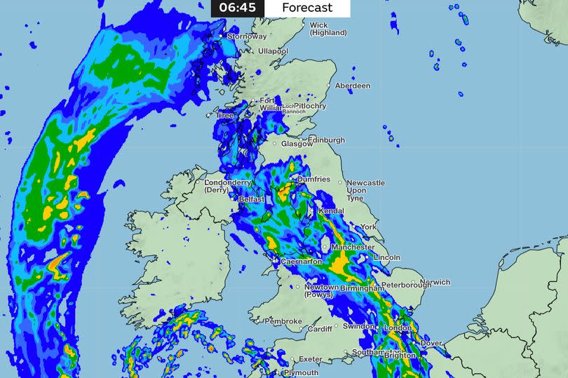
The Met Office has issued a stark warning to Brits as a 750-mile rainstorm is set to hit the UK this week, with an estimated 6mm of rainfall expected every hour. Weather warnings for rain have been put in place by the Met Office, covering most of Northern Ireland, south Wales, and Devon and Cornwall.
The heavy downpour is predicted to begin this afternoon (Monday) and continue into Tuesday morning, with forecasters warning of potential flooding due to the relentless rain.
The scale of the impending deluge becomes even more daunting when viewed on the Met Office's weather map for Tuesday morning. Spanning from Dover in Kent all the way up to Tobermory in Scotland - a distance of roughly 750 miles - the rain is anticipated to affect many of Britain's major cities including Manchester, Birmingham and London as it sweeps across the country from the south west.
Read more: 91-day DWP warning
The Met Office's forecast for today and the rest of the week states: "Most northern and eastern areas will be fine with some warm sunshine. A few showers are expected across Scotland."
"Meanwhile, persistent rain feeding across Northern Ireland, Wales and southwest England. Rain across the north and east easing on Tuesday. Otherwise a mix of sunny spells and showers across the UK, the showers locally heavy and thundery. Warm in the sunshine.", reports the Mirror.
"Changeable with showers developing by day across the UK through the end of the week and over the weekend. The heaviest showers and greatest risk of thunderstorms across southern parts. Temperatures generally around or just a little above average, though with winds tending to be light, still feeling warm in sunnier areas."
"Over the weekend there are signs showers may start to ease from the north with drier, more settled conditions probably becoming established for a time. Confidence lowers into the following week with signals unclear how prolonged the influence of higher pressure will be."
"So after a potentially more settled spell of weather, unsettled conditions are likely to return during the week with the wettest conditions in the west. Above average temperatures are more likely than below."
It comes after temperatures exceeded 24C across the UK on each of the past three days over the weekend. The mercury hit 25.9C on Saturday in Herstmonceux, East Sussex, and 24.6C in St James' Park in central London on Friday.
West Midlands weather forecast
The Met Office says expect weather to be largely dry with sunny spells but heavy rain later.
Today
Some cloud to start but breaking up leaving a dry day with sunny spells, though not feeling as warm as Sunday. Light winds, turning breezier during the afternoon. A chance of some rain in the far west by late-afternoon. Maximum temperature 21 °C.
Tonight
Turning wet this evening as rain spreads in from the west overnight, this heavy and persistent at times. Winds becoming brisk, particularly amongst heavier downpours. Mild. Minimum temperature 12 °C.
Tuesday
Heavy rain during the morning, then generally drier by the afternoon with some sunshine, though a risk of the odd shower. Lighter winds and feeling pleasant in the sunshine. Maximum temperature 18 °C.
Outlook for Wednesday to Friday
Unsettled with sunny spells and showers. Showers may be heavy and possibly thundery at times. Still warm where you catch the sunshine though feeling cooler than last week.

