
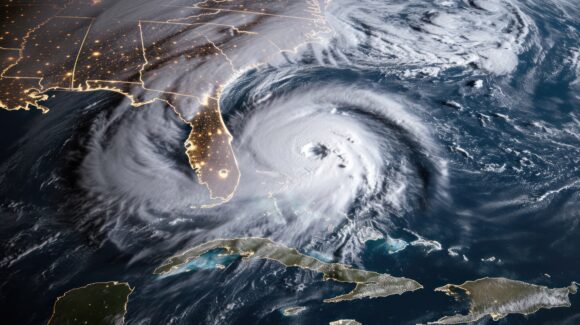
Multiple computer models from forecasting organizations across the globe have predicted a very active hurricane season starting next month, spelling trouble for Florida and much of the Eastern United States.
The models aren’t wrong, said Phil Klotzbach, a senior research scientist at one of the best known of those organizations, the Department of Atmospheric Science at Colorado State University.
“There’s a lot of excitement and nervousness about this year’s hurricane season,” Klotzback said Wednesday at the Target Markets Program Administrators Association’s Mid-Year Meeting in Tampa.
Klotzback and fellow researchers have poured decades of weather data into modeling efforts. As of last month, CSU’s modeling shows a range in the number of storms in the Atlantic Ocean, with 23 as the mid-point in the range. That’s well above the average season, which produces about 14 storms.
About 11 of those 2024 storms will probably become hurricanes – five of which will be major.

And the most likely landing spots for those storms are along the east coast of Florida and elsewhere on the Eastern Seaboard.
One reason is the weather phenomenon known as El Nino, which produces a warm band of water off the west coast of South America and tends to produce high-altitude wind shear, which generally takes the edge off the winds of Atlantic hurricanes. But this year, the evidence shows that El Nino is transitioning to its sister phenomenon, La Nina, which usually results in more and stronger hurricanes.
Combine that with significantly warming waters off the west coast of Africa, where hurricanes form, and much warmer Atlantic, Caribbean and Gulf waters and it all points to a potentially record-breaking storm season.
“We’re very confident this year we’re going to see well above normal hurricane activity,” Klotzbach said.
It’s not just the temperatures on the surface of the ocean that are rising. New data show that even deep down, the heat content of waters is rising – and rising faster than in previous years, he noted.
“We’re going to have one of the warmest years on record in the Atlantic,” he said. “Basically, the die is already cast. We’re so far ahead of schedule.”
Klotzbach said that some data now posits a 62% chance of a major hurricane on the East Coast in the next few months. For eastern Florida, the probability is up to 75%.
“For insurance, the dice are loaded for a big impact this year,” he said.
And when a major storm makes landfall, the property damage and insurance losses are likely to be much greater than in previous large storms. Klotzbach showed how computer models can take into account not just a larger population along vulnerable spots of the U.S. coast, but also inflation and a steady increase in wealth and the value of properties in those areas.
He explained that the powerful, 1926 hurricane that struck south Florida caused some $80 million in damage. If that same storm were to hit the same area today, losses could easily reach $200 billion.
If there was a bright spot for some of the hurricane-battered Southeast states, it is that the Atlantic north of the Equator is warmer than just south of the Equator. That scenario tends to push storms more to the north, toward the east coast of Florida and above – and away from the Gulf of Mexico.
He also noted that mitigation and fortification are the best hopes for those in the path of the coming tempests. Evidence has shown that after 2022’s Hurricane Ian, homes in southwest Florida that were constructed in accordance with newer building codes, especially those homes that were elevated above the storm surge and flood lines, fared much better in the Category 4 storm than did older structures.
Klotzbach and CSU will post an updated 2024 hurricane forecast on June 11.
Was this article valuable?
Here are more articles you may enjoy.
 New Language in California Budget Seeks to Expedite Insurance Rate Filing Approvals
  These Flight Routes Suffer the World’s Worst Turbulence
  Property-Catastrophe Reinsurance Rates Drop by 5% at June Renewals: Howden Re